
(No.5, Vol.7,Oct-Nov 2017 Vietnam Heritage Magazine)
Nho Que winding around mountains

Nho Que river beneath the mist

Nho Que River in afternoon sun

Once upon a time, a huge torrent of water suddenly rushed into the valleys of Ha Giang Mountains. Here the violent flow was blocked by a colossal rock. The River God asked the Mountain God to move aside for the water to bring life to the barren land on the other side. The Mountain God pretended to be deaf and stayed put. Seeing what was going on, the King of Heaven ordered the Thunder God to settle the matter. At night, the Thunder God raised his sword, and the sky brightened in an eye blinding lightening. He swung down the sword, and the earth trembled under a deafening thunderbolt. The rock was split into two, and the blocked body of water rolled through. Vegetation grew lush green along the flow.
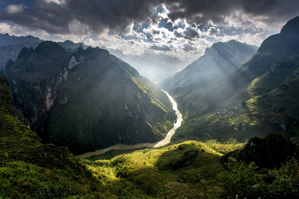
That’s how legends go about Nho Que River in Ha Giang Province. The 192km long river takes its waters from China, passes the border at Lung Cu, goes through Dong Van and the famously dangerous Tu San Gorge, then goes along Ma Pi Leng Pass to MeoVac to finally turn southeasterly into Cao Bang territory and pours into Gam River. This 50km long section provides water for a 6,000km2 basin.
Starting at the height of 1,200m above sea level, the river section in Vietnam goes through a spectacular landscape, rushing down steep slopes, 18,7 per cent at times, passing deep gorges between cloud covered mountains, rumbling down high falls, and winding tortuously in lush valleys between terraced paddies. Wild, majestic and picturesque, Nho Que is the most talked about name among famous places of Ha Giang – one of the most visited provinces of the northern highlands.
The Tu San Gorge section of Nho Que River is considered the most spectacular and monumental.
According to the website of Dong Van Tourist Information Centre, 700-800m deep, 1.7km long Tu San Gorge is the deepest gorge of Vietnam and probably of Southeast Asia, located within the most impressive area of the Dong Van Rocky Plateau, one of the World’s Geological Parks.
The most famous place along Nho Que River is Ma Pi Leng Pass, considered one of the most perilous of the Northwest highlands. Under a 1,800m high above sea level peak, which is always hidden in clouds, the 20km long pass is dubbed the heart of Dong Van Rocky Plateau. Ma Pi Leng Pass is a section of the Road of Happiness which connect Ha Giang City, Dong Van and Meo Vac township.
Ma Pi Leng top is considered one of Vietnam’s most beautiful vantage points for landscape viewing. Many tourists couldn’t help exclaiming that they were mesmerized by the view of range after range of mountains, with a tiny silk band of Nho Que bending sinuously deep down below, seen from Ma Pi Leng top.
Tu San Gorge and Ma Pi Leng Pass belong to the Complex of Ma Pi Leng Regional Geological Heritage. Scientists say that the Ma Pi Leng Geological Region combines tectonic, geomorphologic, strata-paleontological types of heritage.
The Ma Pi Leng area covers 3 communes, Pai Lung, Pa Vi and Xin Cai, all belonging to Meo Vac District of Ha Giang Province. It has been named a national scenic site since 2009 by the Ministry of Culture, Sports and Tourism.
It is home to a number of ethnic minorities such as Hmong, Dao and Tay. Each group has its own, unique culture. They live in remote solitary villages built on hill slopes that look really desolate.
To get more impressions, it’s best to start exploring Nho Que from Lung Cu where the river enters Vietnam. There is a 15km long trail from Lung Cu to Tu San Gorge and Ma Pi Leng that runs alongside Nho Que River. Cleared by the locals, the rugged, narrow and deserted path hangs between sheer rock face and abyss with many steep slopes and abrupt turns… as if designed for strong limbs and hearts.
Lung Cu Commune of Dong Van District is about 160km from Ha Giang City, up the national highway 4C. Everyday there are many buses that go from Ha Giang City to Lung Cu. One can also hire a motorbike in Ha Giang City to ride there.
,,
,,